
Anfeh features the remnants of a lost and massive Crusader fortress.
Toponym
Anfeh holds several designations:
Ampi, mentioned several times in the Tell Amarna letters during the 14th century BC.
Ampa, mentioned in the 7th century BC by the Assyrian king Esarhaddon.
Castrum Nephin in mari fere totum – meaning “the Castle of Nephin built in the sea”, as mentioned by German historian Burchard de Mont-Sion in 1283.
Nephin, derives from Enfeh, a Frankish designation meaning the peninsula cap.
Anfeh is an Arabic designation meaning the nose, the shape of the cap.
Timeline
As Anfeh witnessed a human occupation since prehistoric times, it became famous during the Crusader period. Being part of the County of Tripoli and one of its lordships, Anfeh was entrusted to the Raynouard family in the mid-12th century by Raymond III, count of Tripoli, in exchange of Tartus that was taken away from the Raynouards and given to the Order of Knights of the Hospital. However, we are not sure if the fortress existed before the reign of the Raynouards. The following timeline presents a brief timeline :
1109 – Anfeh was conquered by the franks in the aftermath of the fall of the city of Tripoli. At the outset, it possibly belonged to the Genoese crusaders
1163 – One of the fortress’ early mentions is attested in the Crusader chronicles. It was controlled successively by Raynouard I, Raynouard II and Raynouard III.
1206 – The fortress was taken by the armies of Bohemond IV of Antioch following a war that lasted months against Raynouard III due to a misconduct by the latter.
1245 – 1260 – The fortress was under the control of a certain Jean de Nephin.
1282 – The fortress suffered from battles among the Crusader fiefs. The Lord of Byblos, Guy II Embriaco, the Genoese, and the Knights Templar rose up against the Count of Tripoli Bohemond VII, but they were brutally crushed. Bohemond VII punished the Genoese by blinding them, and he buried alive the Lord of Byblos and his family in the Fort.
1289 – Although the fortress was never conquered by the Arabs, the Franks had to evacuate it when the County of Tripoli fell to the Mamluk Sultan Qalaoun, who eventually took the fortress and dismantled it completely.
Consequently, the peninsula lost its military importance and was used around the 19th century into salines. The mass production of sea salt at Anfeh would decrease by the beginning of the 1990s.
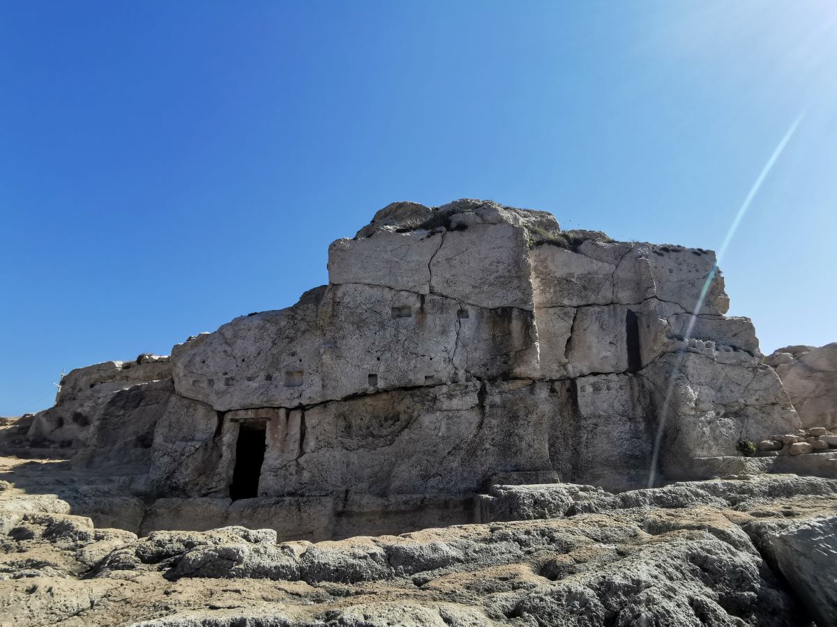
Structure
The castle was erected on a peninsula measuring about 400x150m.
Rectangular in shape, it was flanked by twelve towers, from which nothing remains. It was isolated from the main land by three ditches that were cut into solid limestone, measuring about 70x10m. The first ditch had a drawbridge pier still standing at its southern end.
The remnants of cisterns and pits can be found on the southern side of the fortress, along with some still intact 3m walls on the western and eastern side. The wall’s blocks were extracted from the ditches themselves where extraction marks are still visible.
In addition to these features, excavations have revealed a heap of spherical stone projectiles of different sizes (and therefore different weights) employed in the so-called trebuchets, the powerful siege engines of that time.
Within the stronghold area, evidence of a domestic occupation comprises remains of walls which constitute complete or almost complete rooms, sometimes as large as 14 × 6 m. The walls are about 40 to 60 cm thick and are built of limestone or sandstone blocks or a mixture of both.
Karim Sokhn
Tour Operator & Tour Guide
References:
https://ifpo.hypotheses.org/11293
Les Chateaux des Croisds en Terre Sainte III, INSTITUT FRANCAIS D’ARCHEOLOGIE DE BEYROUTH, BIBLIOTHEQUE ARCHEOLOGIQU ET HlSTORIQUE, TOME XC


